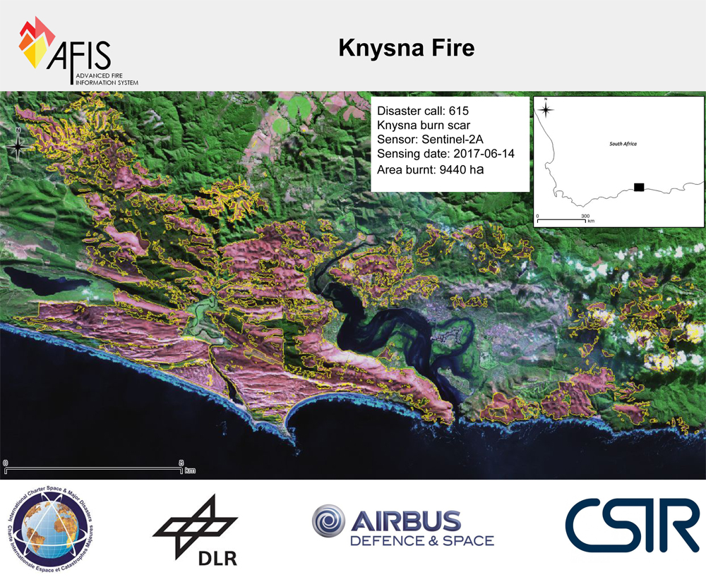
The fires in the Garden Route in June 2017 caused unprecedented destruction in Knysna, Plettenberg Bay and Thornhill near Port Elizabeth. The CSIR provided direct support to the disaster personnel on the ground through its Advanced Fire Information System (AFIS) and the organisation is now supporting efforts to rebuild the area by mapping the burnt area for post-disaster assessments.
Lufuno Vhengani, a CSIR Earth observation technologist, has been developing a system for automated fire scar mapping using Landsat-8 and Sentinel-2A satellite data for several years.
“In the case of big fires in South Africa, we are always prepared to produce maps of the burnt areas that indicate the extent and severity of the burns whenever there is a Landsat-8 or Sentinel-2 overpass over the area of interest. However, sometimes we have to wait for days as the data may be obscured by clouds. Once we get an image that is clear enough to use, we run a change-detection process that generates burn scars. This process compares burnt area indices derived from pre-fire and post-fire scenes,” says Vhengani.
Extracting burn scars with remote sensing data is more practical than measuring the damage on the ground. It provides a precise evaluation that serves as a baseline from which to measure vegetation recovery.
“We produce a burn scar map using data from specific wavelength bands. The short-wave infrared band is useful for detecting the formation of charcoal and the loss of moisture. On the other hand, the near infrared band is sensitive to chlorophyll formation. A remote sensing index using these two bands will discriminate between burnt and unburnt areas.
“Our challenges include the masking out of clouds for data from the Sentinel-2A satellite. Agricultural fields that have been harvested or prepared for sowing might also have the same spectral signature as a burn scar. I try to address this by assigning a low-confidence flag to detected burnt areas in agricultural fields.”
CSIR remote sensing specialist, Linda Kleyn, says that in the days before the fires, the local fire protection agencies in the Cape, which subscribe to AFIS, would have been alerted to the fire danger levels in the area. “There were big storm warnings in the Cape and during the build-up, there were berg winds and temperatures in the 30s.”
The CSIR’s AFIS system shows high danger areas in red. Once the fires are detected with the satellite data, subscribers receive alerts on their mobile phones.
“With the very high winds, the fires moved very quickly. The satellites cross the region about eight times per day, so it may happen that the there are gaps of hours between them. In most cases, people on the ground would be the first to be alerted. AFIS is also able to alert the subscribers to more remote fires, indicating how they move,” says Kleyn.
The burn scar data is now used by various stakeholders such as the insurance industry, forestry companies and by the Southern Cape Fire Protection Association and associated municipalities, conservation organisations and disaster management agencies in the Knysna and Plettenburg Bay area. Areas of high erosion risk are identified based on the fire scar, burn severity and slope. Areas where wildlife can find refuge can also be identified.
“They need to know how many hectares have burned, which classes of land cover, for example crop, forests or urban areas. We also need to establish the severity of the burns,” says Kleyn.
“Some alien plants burn at a much higher temperature than indigenous vegetation, such as milkwood forests. Botanists have warned of the fire risk in the area due to high fuel loads and very dry conditions. Alien plants provide fuel that changes the behaviour of the fire. Already on the images, there are indications that indigenous vegetation was more resistant to the fires.”
Kleyn says that these images can also be over-laid in urban areas to assess where buildings burned down. “The researchers are able to zoom into areas at high resolution. The data may help to interpret where fires started and how they entered suburbs.”
Please visit www.afis.co.za for more information